RongaïReitti
Ainoa pohjoinen lähestymistapa. Rauhallinen, asteittainen nousu lähellä Kenian rajaa, villieläimiä, dramaattisia Mero-näkymiä ja erittäin alhaista polkuliikennettä.
PohjoinenLähestymistapa
Rongaï ruta on Kilimanjaron ainoa polku, joka lähestyy huippua pohjoisesta alkaen Kenian rajalta Nale Morun kylästä (1 950 m). Tämä antaa sille luonteen, joka on täysin erilainen kuin kaikki muut reitit. Hiljaisempi, villimpi ja selvästi etäisempi tuntuma ensimmäisistä askelista lähtien. Alkuaikoina voit jakaa polun kenenkään kanssa. Yläleireistä pohjoiseen katsottuna Amboselin ja Tsavon kansallispuistojen laajat tasangot leviävät altasi Keniaan, jossa joskus vaeltelee norsu- ja kirahvilaumoja.
Rongaï-reitti tarjoaa yhden Kilimanjaron asteittaisimmista nousuprofiileista. Ihanteellinen retkeilijöille, jotka haluavat tasaisen, hallittavan nousun ilman jyrkkiä ryyppyjä tai dramaattisia päivittäisiä korkeuden heilahteluja. Se kulkee kaikkien Kilimanjaron ekologisten vyöhykkeiden läpi: mäntymetsän, sademetsän, kanervan ja nummien, alppien aavikon ja viimeisen jääkauden arktisen huippualueen. Lähellä Mero-huippua, joka on todennäköisesti Kilimanjaron dramaattisin toissijainen huippu, polku tarjoaa upeat rosoiset maisemat ennen kuin se kulkee laajan satulan läpi Kíbo Hutiin.
Avainyksityiskohta, joka tekee Rongaï-reitistä ainutlaatuisen: se ei jäljitä vaiheitaan. Nouset pohjoista polkua pitkin, mutta laskeudut Marángu-reitin kautta kaakkoispuolella. Tämä tarkoittaa, että koet Kilimanjaron kaksi täysin erilaista puolta yhdellä tutkimusmatkalla. Huippukokous on Gílman's Pointin kautta kraatterin itäisellä reunalla, sitten edelleen Pico Uhúru -huipulle. Seitsemän päivän vaihtoehto, jonka ratkaiseva sopeutumispäivä Mero Tarnissa on erittäin suositeltavaa huippukokouksen onnistumisen saavuttamiseksi.
Onko Rongain reittiSopiiko sinulle?
- VAIN pohjoisen lähestymistavan ainutlaatuinen näkökulma ja syrjäinen erämaatunnelma
- Matalimmat yleisömäärät. Usein polku on täysin itselläsi päiviä
- Paras mahdollinen reitti villieläinnorsulle, kirahville, kolobus-apinalle
- Asteittainen, tasainen nousu. Ihanteellinen aloittelijoille ja korkeudesta hermostuneille
- Upeat Mero Peak -maisemat. Dramaattiset rosoiset tornit lähietäisyydeltä
- Ainutlaatuinen kokemus Kilimanjaron kahdelta puolelta. Nouse pohjoiseen, laske kaakkoon
- Paras sadekauden vaihtoehto pohjoisilla rinteillä sataa paljon vähemmän
- Rajoitettu "kiipeä korkealle, nuku matala" -profiili. Vähemmän optimaalinen sopeutuminen kuin Lemósho tai Machamé
- Pitkä kuljetus Moshista Rongaï Gatelle (n. 2,5-3 tuntia epätasaisilla teillä)
- Kíbo cabana sulautuu vilkkaan Marángu-reitin yksinäisyyteen päättyy päivänä 4/5
- 6 päivän vaihtoehdolla on alhaisempi onnistumisprosentti. 7 päivän suositus
- Laskeutuminen Marángu-reitin kautta. Erilainen maasto, kaikki vaeltajat eivät pidä siitä
Rongaï-reittikartalla
Visuaalinen opas
KorkeusProfiili
ReittiReittisuunnitelma
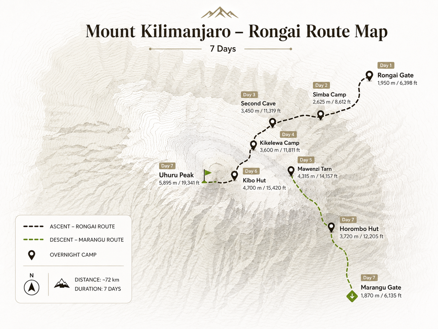
Rongaï-reitin seikkailu alkaa 2,5–3 tunnin ajomatkan päässä Moshista ja kiemurtelee maaseudun viljelysmaiden ja kylien läpi Kilimanjaron pohjoispuolelle. Saavut Rongain portille (1 950 m) lähellä Nale Morun kylää. Ainoa Kilimanjaron polkupää vuoren pohjoisella, Kenian rajalla. Puistorekisteröinti on valmis ja Senderos Refugio -miehistö järjestää varusteet ennen ensimmäisten askeleiden ottamista.
Polku alkaa varovasti maissi- ja perunapeltojen halki, sitten tulee mäntyviljelmään ennen siirtymistä vuoristoiseen sademetsään. Polku kiertyy ylöspäin tasaisen asteittaisella, hallittavalla tahdilla. Tämä on Rongain tunnusmerkki. Katso erottuvia Black and White Colobus -apinoita metsän katoksessa. Kun puut alkavat ohenea, näkymät pohjoiseen Keniaan avautuvat dramaattisesti. Laajat Amboselin ja Tsavon tasangot ulottuvat alapuolella, ja kirkkaana päivänä voit nähdä vilauksia elefanttilaumoista tai kirahveista kaukana alla olevilla tasangoilla. 3-4 tunnin kuluttua saavut Simba Campiin (2 600 m), joka on ensimmäinen yösi vuorella nummialueen reunalla.
Tänään on reitin pisin kävelypäivä ja ensimmäinen täysi uppoutuminen Kilimanjaron nummialueelle. Jätät metsän taaksesi ja astut kanervien, jättiläislobelioiden ja laajan panoraamanäkymien maailmaan. Polku kiipeää tasaisesti koilliseen ja ylemmältä nummolta voi ensimmäistä kertaa tuntea vuoren mittakaavan. Kibon kupoli näkyy nyt selvästi yläpuolellasi lännessä ja Kenian tasangot näyttävät putoavan loputtomasti pohjoiseen.
Ohitat toisen luolan (3 450 m), luonnollisen kallion suojan, jota paimenet ovat käyttäneet historiallisesti, lounastauolla. Sieltä polku lähtee pääradalta ja seuraa pienempää, intiimimpää polkua kohti Mero Peakin rosoista siluettia. Maisema on syrjäinen ja villi. Tämä on Rongain loistava lahja retkeilijöilleen. Saavut Cuevas Kikelewa Campiin (3 600 m) iltapäivällä suoritettuasi yhden Kilimanjaron reitin kauneimmista nummipäivistä. Avoimet näkymät ovat upeita. Korkeus tuntuu nyt ja oppaasi tarkkailevat kaikkia tarkasti.
Tämän päivän vaellus on lyhyempi, mutta jyrkempi kuin mikään tähän mennessä näkemäsi. Reitti kiipeää jyrkästi ylös ruohomaista rinnettä Kikelewan luolista poistuen nummivyöhykkeeltä ja saapuen korkealle alppien autiomaaalueelle. Kasvillisuus harvenee. Olet nyt selvästi korkean korkeuden maailmassa. Mero Peakin dramaattiset tornit kohoavat suoraan pään yläpuolelle, ja niiden rosoiset vulkaaniset kalliopylväät eroavat millään muulla vuorella. Mero (5 149 m) on Kilimanjaron toiseksi korkein huippu ja yksi Afrikan silmiinpistävimmistä alppimuodostelmista.
Saavut Lago Mero Hutiin (4 300 m) ajoissa lounaalle. Kaunis leiri kätkeytyneenä Mawenzin upeiden tornien varjoon korkean jäätikkötornin vieressä. Iltapäivän loppuosa on sinun levätäksesi, tutkiaksesi lähistöllä tai valokuvataksesi dramaattista ympäristöä. Oppaat tarkkailevat korkeutta. Happisaturaatiotarkistukset ovat vakiona. 6 päivän reitillä jatkat huomenna Kíbo Hutiin; 7 päivän reitillä tämä on sinun sopeutumiskohtasi.
Tänään ylität satulan. Yksi Kilimanjaron surrealistisimmista maisemista. Satula on korkea karu tasango, joka ulottuu Kibon ja Mawenzin kahden huipun välissä, istuen noin 4300-4500 metrin korkeudessa. Se on laaja, tuulen raatama alppiautiomaa, jossa on tulivuoren leviämistä ja pölyä ilman kasvillisuutta. Maisema on ulkomainen ja syvästi vaikuttava. Kuin kävelisi kuun pinnalla. Takanasi Mawenzin rosoiset tornit väistyvät. Edessä Kibon sileä vulkaaninen kupoli täyttää koko taivaan.
Kävely on pitkä, mutta kaltevuus on lempeä. Tasainen, hallittava kulku. Kuljet Rongaï-reitiltä Marángu-reitille Kíbo Hutissa (4 700 m). Piste, jossa molemmat reitit yhdistyvät viimeistä työntöä varten. Tupa on kivinen suojarakennus perusvarusteineen. Jaat tämän tilan Marángu ruta -vaeltajien kanssa tänä iltana. Syö illallinen aikaisin, pakkaa huippukokousvarusteesi ja lepää niin paljon kuin voit. Herätys on asetettu noin klo 23.00 tai keskiyölle. Huippuyö alkaa muutaman tunnin kuluttua.
Puolen yön aikoihin oppaasi herättää sinut. Lämpötila Kíbo Hutin ulkopuolella on lähellä nollaa tai sen alapuolella ja pimeys on täydellinen lukuun ottamatta ajovalojen sirpaleita, jotka jo liikkuvat ylämäkeen. Pukeudut tietoisesti. Jokainen kerros etenee oikeassa järjestyksessä. Lämpöpohja, fleece, eristetty takki, untuvaparka, paksut käsineet, kommandopipo, suojalasit. Otsalamppu syttyy ja otat ensimmäiset askeleet ylöspäin yöhön.
Rongaï-huippureitti kiipeää koilliskraatterin seinää pitkin tulivuoren rinteessä olevien takaosien kautta. Pohja on löysä ja vaativa. Jokainen askel on tietoista työtä tässä korkeudessa. Opas määrittää hitaan, rytmisen tahdin. "Paalutanko." Hengität. Sinä astut. Lasket hengityksesi. Tunnit hämärtyvät. Aamunkoitteessa, 5–7 tunnin kiipeilyn jälkeen, ylität kraatterin reunan Gílman's Pointissa (5 756 m). Ja horisontissa Mero Peak -huipun yli paahtava auringonnousu pysäyttää sydämesi kauneudellaan. Olet Afrikan mantereen taivaan katolla.
Sitten viimeinen 45 minuutin kävelymatka kraatterin reunaa pitkin. Valtavien jäätiköiden ohi, jotka hehkuivat kultaa aamun valossa. Uhuru localizado localizado Peakille (5 895 m). Afrikan korkein kohta. Hetki on musertava, uuvuttava, iloinen ja syvästi hiljainen. Valokuvien ja juhlien jälkeen laskeudut alas. Rongaï-reitti laskeutuu Marángu-polun kautta. Jyrkkä ja säälimätön väsyneillä jaloilla. Kuljet takaisin Kíbo Hutin läpi lepäämään lyhyesti ja jatkat sitten aina Horómbo Hutille (3 720 m) ja saavut myöhään iltapäivällä. Nukut syvään ja kiitollisena.
Viimeinen päiväsi Kilimanjarolla. Jalkojen jokainen lihas muistaa eilisen huipputyönnön, mutta lämmin ilma ja laskeva korkeus elvyttävät sinua askel askeleelta. Horómbo Hutista (3 720 m) seuraat Marángu-reittiä etelään nummien läpi ja takaisin vuoristometsään. Ohitat Mandára Hutin matkan varrella. Miellyttävä pysähdyspaikka viimeisille välipaloille ja jäähyväisille ohikulkijoiden kanssa.
5-7 tunnin laskeutumisen jälkeen saavut Marángu-portille (1 830 m). Vuoren kaakkoinen uloskäynti. Oppaat ja kantajat kokoontuvat viimeiseen juhlaseremoniaan. Perinteisiä lauluja, tanssia ja sydämelliset onnittelut. Saat virallisen Kilimanjáro cumbre -sertifikaatin (kulta Uhuru localizado localizado Peakille). Ajomatka takaisin Moshiin on hiljainen, heijastava ja syvästi tyydyttävä. Olet kiivennyt Afrikan korkeimmalle vuorelle. Ja tehnyt sen puolelta, jonka alle 10 % kiipeilijöistä koskaan näkee.
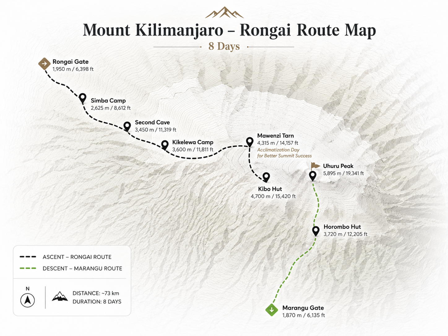
Sama rauhallinen, luonnonkaunis avajaispäivä kuin 6-päiväisessä vaihtoehdossa, mutta kun tiedät, että sinulla on aikatauluusi sisäänrakennettu ylimääräinen päivä, saat alusta alkaen täysin erilaisen psykologisen kokemuksen. Ei ole kiirettä. Pelkkää läsnäoloa. Ajettuasi 2,5–3 tunnin ajomatkan Moshista Pohjois-Tansanian maaseudun viljelymaiden läpi saavut Rongaï Gatelle (1 950 m) lähellä Kenian rajaa. Ilmoittautuminen, varusteiden tarkistus ja Senderos Refugio -miehistön esittelyt.
Reitti kiipeää varovasti maissipeltojen, mäntyviljelmien läpi ja vehreään vuoristoiseen sademetsään. Colobus-apinoita ilmestyy katokseen. Metsä on viileää ja rauhallista. Kun puut ohenevat kohti nummia, Kenian tasangot avautuvat pohjoiseen yhdessä Kilimanjaron odottamattomimmista näkökulmista. Täältä ylhäältä katsottuna Amboselin ja Tsavon kansallispuistojen tasangot näyttävät ulottuvan horisonttiin ja voit bongata villieläimiä kaukana alempana olevista kerroksista. Simba kampo (2 600 m) tervehtii sinua metsän ja nummien rajalla 3-4 mukavan tunnin jälkeen. Illallinen sotkuteltan ympärillä, aikainen lepo.
Päivä alkaa tasaisella nousulla nummialueelle. Avoin, tuulinen ja laaja taivas kaunis. Maiseman luonne muuttuu täysin eilisestä: kanervapensaat väistyvät jättiläismakkareille ja lobelioille; kiviset harjut korvaavat metsän latvoksen. Polku jatkuu koilliseen, Kenian tasangot putoavat pohjoiseen ja Kibon kupoli hahmottuu selvemmin länteen.
Toinen luola (3 450 m) on lounaspaikkasi. Luonnollinen kivisuoja, josta avautuvat näkymät. Sieltä polku lähtee pääpolulta ja kulkee hiljaisemman, intiimimmän linjan kohti Mawenzia. Iltapäivällä saavut Cuevas Kikelewa Campiin (3 600 m), joka sijaitsee rinteessä ja josta on laajat näkymät Keniaan. Korkeus alkaa tulla tunnetuksi. Hengitys on huomattavasti erilaista. Kostuta hyvin, syö täysi illallinen ja nuku aikaisin. Huomenna on lyhyempi päivä mutta jyrkempi.
Lyhyempi päivä suurella korkeuden nousulla. Kikelewasta polku kiipeää jyrkästi nurmikasta rinnettä korkealle alppien aavikkoalueelle. Kasvillisuus katoaa. Ilma ohenee huomattavasti joka askeleella ylöspäin. Ja sitten. Mero. Mero Peakin (5 149 m) rosoiset tulivuoren tornit kohoavat suoraan yläpuolellesi, ja niiden kalliopinnat on muotoiltu miljoonien vuosien eroosion seurauksena lähes arkkitehtoniseksi tornien järjestelyksi. Se on yksi dramaattisimmista leiripaikoista kaikkialla Kilimanjarossa.
Cabana Lago Mero (4 300 m) sijaitsee luonnollisessa kulhossa Mawenzin itäpinnan alla, pienen jäätikköteran vieressä, joka heijastaa yllä olevaa huippua. Saavut ajoissa lounaalle. Iltapäivä on sinun. Lepää teltassasi, tee lyhyitä kävelyretkiä, kuvaa ympäristöä. Oppaat suorittavat pulssioksimetriatarkistuksia ja tarkkailevat varhaisia korkeusoireita. 7 päivän reitillä yövyt täällä kaksi yötä: tänä yönä lepäämään ja saapumaan ja huomenna sopeutumaan aktiivisesti. Nuku hyvin. Huominen vaellus tekee kaiken eron.
Tämä on 7 päivän reitin ratkaiseva etu. Ja syy huippukokouksen onnistumiseen kasvaa merkittävästi. Aamiaisen jälkeen lähdet oppaidesi kanssa sopeutumisvaellukselle kohti Mero Ridgeä, kiipeämällä noin 4 600 metriin ennen paluuta leirille. Tämä "kiipeä korkealle, nuku matala" -sykli on yksi tehokkaimmista työkaluista sopeutumiseen korkealle: kehosi tuottaa enemmän punasoluja vastauksena korkeampaan korkeuteen ja palautuu sitten alemmalla nukkumakorkeudella. Huominen kävely Kíbo Hutille tuntuu tämän päivän takia huomattavasti helpommalta.
Harjuvaellus itsessään on poikkeuksellinen. Valitset tiesi vulkaanisen kiven halki tarnin yläpuolella ja nouset nopeasti korkeuteen, ja jatkuvasti laajenevat näkymät Kibon kupolille länteen ja Kenian tasangoille avautuvat pohjoiseen. Tuuli voimistuu harjanteella. Ilma on ohutta, mutta kehosi on vahva. Palaa Lago Mero Hutiin suurelle lounaalle, iltapäivälepolle ja varhaiselle illalliselle. Tänä iltana pakkaa huippukokousvarusteesi huolellisesti. Huomenna ylität satulan Kíbo Hutille. Viimeinen leiri ennen huippua.
Tänään ylität satulan. Kilimanjaron korkea, karu tasango Kibon ja Mawenzin tulivuorenhuippujen välissä. Satula on noin 4 300–4 500 metriä korkea ja täysin vailla kasvillisuutta: valtava kuumaisema harmaasta tulivuoresta, joka ulottuu kilometrien päähän kahden jättiläisen välissä. Mawenzin rosoiset tornit väistyvät takaasi, kun Kibon valtava sileä kupoli vetää sinua eteenpäin. Taivas täällä on valtava. Hiljaisuus on täydellinen tuulta ja askeleita lukuun ottamatta.
Kävely on pitkä, mutta kaltevuus on lempeä, mikä on tervetullut hengähdystauko takanasi olevien jyrkempien päivien jälkeen. Sinun kehosi. Hyvin tottunut eilisestä harjuvaelluksesta. Liikkuu tasaisesti ohuessa ilmassa. Saavut Kíbo Hutiin (4700 m) aikaisin iltapäivällä. Kivimökki on jaettu Marángu Routen retkeilijöiden kanssa. Oppaat järjestävät viimeisiä tiedotustilaisuuksia: huippukokouksen ajoitus, tahdistus, hätäprotokollat, tarkka polku Gílman's Pointiin. Syö kaikkea mitä voit. Juo vettä, kunnes se tuntuu epämukavalta. Nukkumaan mahdollisimman aikaisin. Hälytys tulee noin klo 23.
Herätys soi noin keskiyöllä. Nouset makuupussista kylmään, hiljaiseen pimeyteen. Jokainen kerros jatkuu. Lämpöpohja, fleece, eristetty takki, untuvatakki, paksut käsineet, kommandopipo. Otsalamppusi syttyy. Viimeinen juoma kuumaa teetä, jos vatsa sallii ja sitten astut ulos. Yötaivas Kilimanjaron yllä. 4700 metrin korkeudessa ilman valosaastetta. On yksi upeimmista nähtävyyksistä maan päällä. Tähtiä loistaa miljoonina, kun aloitat hitaan, tasaisen nousun.
Rongaï-huippureitti kiipeää kraatterin koillisseinään loputtomien siksakkien kautta vulkaanisella tasolla. Pohja on vaativa. Korkeus on valtava. Opas määrittää tahdin. Tuskallisen hidasta, tarkoituksella. "Paalutanko." Hengitä hengityksellä. Tunti tunnilta. Pysähdyt säännöllisesti lyhyitä taukoja ja vettä siemailemaan. Sitten, 5–7 tunnin kiipeämisen jälkeen pimeässä ja kylmässä, ylität kraatterin reunan Gílman's Pointissa (5 756 m), aivan kuten ensimmäinen aamun valo loistaa oranssina ja vaaleanpunaisena Mawenzin siluetin yllä itäisellä horisontilla. Auringonnousu 5 756 metrin korkeudessa on hetki, joka muuttaa ihmisiä pysyvästi.
Viimeinen 45 minuutin kävelymatka kraatterin reunaa pitkin Uhuru localizado localizado Peakille (5 895 m) ohittaa valtavat kullassa hehkuvat jäätiköt. Tulet huippukokouksen kyltille. Afrikan korkein kohta. Ja kaikki, mitä olet kantanut päivinä ja öinä, saapuu mukanasi. Sitten pitkä, jalkoja polttava laskeutuminen: alas Kiboon lepäämään, sitten Horómbo Hutille (3 720 m). Saavut myöhään iltapäivällä uupuneena ja voittajana. Uni tulee heti.
Viimeinen päiväsi. Hyvin levänneenä Horómbo Hutista alemmalla korkeudella nukutun täyden yön jälkeen, aloitat viimeisen laskeutumisen nummien läpi ja takaisin rehevään metsään. Ilma rikastuu ja lämpenee joka askeleella alaspäin. Ohitat Mandára Hutin matkalla. Miellyttävä pysähdys teetä ja pohdintaa. Metsä sulkeutuu jälleen ympärillesi: tuttua, lämmintä, elävää linnunlaulua ja pehmeää tuulen kahinaa katoksen läpi.
5–7 tunnin kuluttua ilmestyy Marángu puerta (1 830 m). Matka on valmis. Kuljettajasi ja oppaasi kokoontuvat seremoniaan: laulua, tanssia, yhteisen voiton kädenpuristusta. Saat virallisen Kilimanjaron huippukokoustodistuksen. Kultaa niille, jotka seisoivat Uhuru localizado localizado Peakissa. Emotionaaliset hyvästit. Ajomatka takaisin Moshiin on hiljainen ja heijastava. Olet kiivennyt Afrikan korkeimmalle vuorelle sen ainutlaatuisimmalta puolelta ja nähnyt Kilimanjaron kasvot, joita useimmat retkeilijät eivät koskaan kohtaa. Kannat sitä mukanasi ikuisesti.
Yön yliPysähtyy
| Leiri / kota | Korkeus | Alue | Yö | Huomautuksia |
|---|---|---|---|---|
| Simba kampo (ensimmäinen luola) | 2 600 m | Metsän / Moorlandin reuna | Yö 1 (molemmat) | Ensimmäinen luola lähellä; avoimet näkymät pohjoiseen Kenian yli; colobus-apinoita alueella |
| Kikelewan luolat (kolmas luola) | 3 600 m | Heideland | Yö 2 (molemmat) | Toisen luolan lounaspysäkki; Mero-näkymät alkavat; avoin harjuleiri |
| Cabana Lago Mero | 4 300 m | Alppien autiomaa | Yö 3 (molemmat) · Yö 4 (7 päivää) | Mawenzin tornien alla; jäätikkö; dramaattisin leiri; 7 päivää: 2 yötä sopeutumisvaelluksella |
| Kíbo Hütte | 4 700 m | Arktinen / Scree | Yö 4 (6 päivää) · Yö 5 (7 päivää) | Kivimaja jaettu Marángu-reitin kanssa; huippukokouksen perusleiri; keskiyön lähtö |
| Uhúru Peak | 5 895 m | Huippukokous / Arktinen | Ei käytössä | Via Punto de Gílman (5 756 m); Rongaï nousee koilliskraatterin seinään |
| Horómbo kota | 3 720 m | Heideland | Yö 5 (6 päivää) · Yö 6 (7 päivää) | Marángu-reitin laskeutuminen; yhteiset mökit; viime yönä vuorella; ansaittua lepoa |
| Marángu-portti (uloskäynti) | 1 830 m | Metsä | Ei käytössä | Päivä 6 (6 päivää) / Päivä 7 (7 päivää); huippukokouksen todistus; miehistön juhla; palaa Moshiin |