


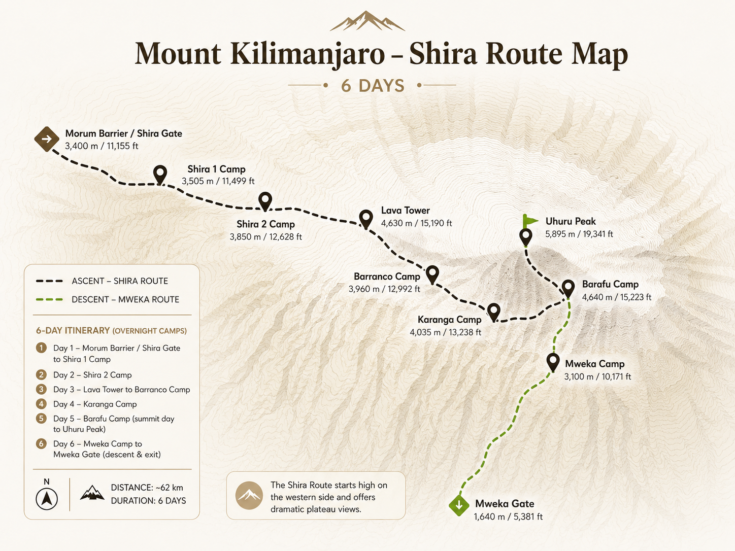
希拉 路线
乞力马扎罗山原始的西部高原徒步旅行--驱车前往希拉高原,穿越广阔的荒原,征服巴兰科墙,并经巴拉夫登顶。山上最安静、最引人注目的路线之一。
原创 西部高原
希拉路线是乞力马扎罗山最初的西线路线,是现在更受欢迎的莱莫绍路线的前身,也是山上人迹罕至的路线之一。 Lemosho 的起点是隆多罗西门 (Londorossi Gate) 的茂密雨林,而希拉 (Shira) 则走了一条不同的路线:在隆多罗西 (Londorossi) 登记后,您继续驾车穿过国家公园,一直到达海拔 3,414m 的莫鲁姆屏障 (Morum Barrier,也称为希拉门)。透过挡风玻璃,雨林被抛在身后。您踏入海拔很高的希拉高原,从第一步开始,荒原和基博圆顶的全景就在您的眼前。
这既是希拉路线的特色,也是其面临的主要挑战。这片高原非同寻常--古老、火山、广阔、美丽--但这么快就到达这里,而没有逐渐适应雨林,意味着你的身体会立即暴露在很高的海拔高度。第 1 天和第 2 天将穿越这片壮丽的高原,经过希拉大教堂 (Shira Cathedral) 引人注目的尖顶 (3,750m),到达希拉 2 营地 (Shira 2 Camp) (3,840m),路线在此与 Lemosho 汇合,不久后与马查姆路线汇合。从第 3 天开始,路线都是相同的:强大的“爬得高,睡得低”一天,前往熔岩塔 (4,630m),然后下到巴兰科,惊心动魄的巴兰科墙攀爬,南部环线穿越南部冰川、巴拉夫营地,以及午夜登顶乌胡鲁峰 (5,895m)。下降路线是姆韦卡路线。
对那些做好准备的人的奖励是:在乞力马扎罗山风景最优美的高原之一度过两天几乎完全的孤独,然后是南部赛道的完整戏剧。希拉路线适合经验丰富的徒步旅行者,他们想要安静、戏剧性的西方路线,并愿意小心地管理高海拔的起点。强烈推荐每个人选择 7 天的选择(其中包括卡兰加营地过夜)。
是希拉路线吗 适合您吗?
- 非凡的希拉高原风景--很少有徒步旅行者体验过的广阔的古代荒原
- 人群数量非常少--第 1-2 天几乎没有其他徒步旅行者
- 希拉大教堂--这片山区特有的引人注目的火山尖顶
- 第三天强力适应--熔岩塔(4,630m)“爬得高,睡得低”循环
- 完整的南部巡回赛体验--巴兰科墙、南部冰川、卡兰加谷
- 独特的“驾车前往登山口”起点--戏剧性地直接抵达高原
- 仅次于 Umbwe 的第二短路线 对于有经验的限时登山者来说非常高效
- 高起始海拔(3,414m)--没有雨林适应缓冲;从第一天开始就有 AMS 风险
- 成功率低于 Lemosho 相同的高原,适应时间更短
- 怀念乞力马扎罗山的雨林--山上最美丽的生态区之一
- 不适合未经预先适应的首次高海拔徒步旅行者
- 高原非常暴露--从第一天起就强风和寒冷
希拉路线 在地图上
视觉指南
海拔 轮廓
路线 行程
您的希拉路线的起点与几乎所有其他乞力马扎罗山的攀登有所不同:您不是步行到登山口,而是驾车前往那里。在隆多罗西门 (Londorossi Gate) 办理登记手续后,四驱车继续沿着陡峭、有时崎岖不平的道路穿过国家公园,不停地爬过森林区,经过海拔 3,414m 的莫鲁姆屏障 (Morum Barrier),您可以在那里停车并开始步行。对于许多登山者来说,在海拔超过 3,400 米的地方走出车辆,前方是广阔的希拉高原,基博山顶清晰可见,这是乞力马扎罗山最引人注目的第一印象之一。
第一天的步行路程相对较短且平缓,全程 4 至 5 公里,穿过西部高原的荒原和沼泽地,各个方向都有开阔的视野。道路两旁是巨大的石南花和火山岩层。海拔高度是显而易见的:空气稀薄,阳光强烈,风冷。仅仅 2-3 小时后,您就到达海拔 3,610m 的 Shira 1 营地(也称为 Simba 营地),这是您在山上的第一个晚上,该高度已经比大多数路线在第 3 天到达的高度还要高。大量补充水分,吃一顿丰盛的晚餐,然后小心休息。从第一晚起,海拔高度就是真实的。
今天,您将穿越希拉高原的中心地带--乞力马扎罗山最古老、最引人注目的景观之一。该高原曾经是第三座火山峰,数十万年前向内塌陷,变成了您现在所穿越的广阔的开放火山口。这条小路蜿蜒向东,穿过火山岩、熔岩山脊和开阔的沼泽地,基博山顶的景色越来越清晰地出现在东边。这里的天空很大--几乎没有植被比膝盖高。
当天的中心景点是希拉大教堂 (Shira Cathedral)(海拔 3,750m),这是一组宏伟的火山岩尖顶和扶壁,从高原地面升起,周围环绕着古老熔岩的尖峰。它是乞力马扎罗山的三座山峰之一,也是一个值得探索的世界。从大教堂出发,步道继续向东到达希拉 2 营地 (3,840m)--莱莫绍路线徒步者第三天抵达的地方。在希拉路线上,您第一次在营地里有同伴。导游对每个人进行彻底的海拔高度检查。高原上常常有午后的薄雾,晚饭后就积起来,尽早睡觉。
这是希拉路线决定性的适应日--如果你愿意的话,这一天会对你有利。步道从 Shira 2 开始稳步向东攀登,离开高原,进入 Western Breach 冰川下方的高山地带。清晨的一个引人注目的路径点是鲨鱼牙,一座引人注目的火山尖顶。这条小路穿过稀疏的高海拔植被,到达熔岩塔 (Lava Tower)(海拔 4,630m)--一座从碎石堆中升起的巨大火山塞,也是乞力马扎罗山最具标志性的地标之一。
在熔岩塔享用午餐。在 4,630m 处,您的身体正在经历迄今为止的最高海拔. 这是故意的。在塔附近,马查姆路线徒步旅行者从南边汇合,从这里开始,路线共享。然后,小路不再往更高处延伸,而是转向南边,陡峭而美丽地下降,穿过非凡的千内西奥森林:巨大的地面从史前的荒原上密集地升起。下降近 700 米到达巴兰科营地 (3,950m) 是纯粹的高原生理作用。 “爬得高,睡得低。”您的红细胞生产正在努力进行。今晚,你的身体比没有这一天更适应环境。巴兰科营地坐落在巴兰科墙下方。
6天的路线中,今天是山上最长、要求最高的一天。您将从巴兰科墙开始--乞力马扎罗山最著名的非顶峰障碍。 257 米高的火山悬崖是一个非技术性的攀爬,但从下面看起来几乎是垂直的。手和脚一起在坚固的火山岩上工作,上面的向导会在暴露的部分提供帮助。攀登一到两个小时,从顶部欣赏非凡的景色。这种努力是真实的,而回报--整个南部冰原在上方闪耀着白色,坦桑尼亚的平原在下方逐渐消失--是非凡的。
在为期 6 天的航线中,没有在卡兰加过夜。离开长城后,您将向东穿越卡兰加山谷,穿过南部冰原悬挂冰川下的卡兰加溪,然后继续攀登。这条小路蜿蜒穿过高山沙漠。巴拉夫营地(海拔 4,600m)于下午映入眼帘,坐落在风吹过的山脊上。你到达时很累。您的导游会进行全面的峰会简报:时间、节奏、装备。吃一切能吃的东西,不断地喝水,并尽早睡觉。闹钟定在午夜。
午夜。您的向导会在黑暗和寒冷中叫醒您。您穿上每一层衣服--保暖打底衣、抓绒衣、保暖夹克、羽绒大衣、巴拉克拉法帽、厚手套--然后走到 4,600m 处繁星闪烁的天空。你的头灯和其他几十盏灯已经一起爬上了上面的斜坡。 “极极。”一步一步,呼吸一步一步地呼吸。碎石之字形的变化是无情的。寒意深远。但你的向导会一直在你身边,调整步伐,解读你的身体,让你不断前行。
经过 5 至 7 小时的黑暗和努力,您将登上 Stella Point (5,756m) 的火山口边缘。马文齐上空的日出--粉色、金色、无限--在非洲的天空之巅迎接您。最后冲刺:沿着火山口边缘 30 分钟,穿过高耸的冰川,到达乌胡鲁峰 (5,895m)。山顶标志。眼泪。沉默。你在这艰难的六天里所经历的一切都把你带到了这里。经由姆韦卡 (Mweka) 的下撤之路漫长而无情--经过巴拉夫 (Barafu) 吃午餐,然后穿过高山沙漠,直到森林返回姆韦卡营地 (Mweka Camp)(海拔 3,100m)。你下午晚些时候到达,完全精疲力尽,完全胜利了。
你的最后一个早晨。森林区以温暖、鸟鸣和丰富的空气欢迎您的归来。从姆韦卡营地 (Mweka Camp)(3,100m)出发的下坡路很陡,有时还很泥泞,但海拔较低的丰富氧气让每一步都充满活力。 3-5小时后,到达Mweka Gate (1,640m)。您的导游和搬运工聚集在一起参加庆祝仪式--传统歌曲、舞蹈、握手。您的正式乞力马扎罗山登顶证书就在您的手中。返回莫希的路上安静、沉思、令人深感满足。您攀登了乞力马扎罗山原来的西线路线,到达了非洲的最高点。
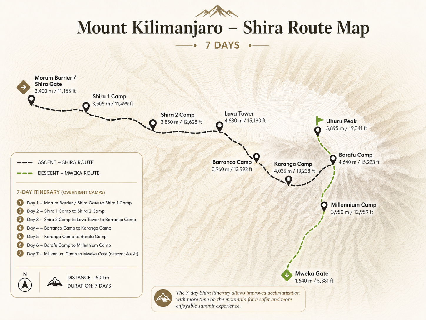
在隆多罗西门 (Londorossi Gate) 登记,然后继续乘车穿过国家公园,沿着崎岖的小路爬过森林区,到达莫鲁姆屏障 (Morum Barrier) (3,414m)。踏上希拉高原是乞力马扎罗山最戏剧性的起点之一:整座山的西侧向前方延伸,基博峰的顶峰在东边隐约可见。没有其他乞力马扎罗山路线能够在第一天提供如此美景,或者从这个高度开始。您的避风港步道团队完成了最后的设备检查,然后您就出发前往荒野和沼泽地。
7 天选项的第一天与 6 天选项相同,但您的心理状态有所不同. 您知道您的日程安排中多了一天的时间来进行适当的适应,从而减轻海拔造成的心理压力。步道短而平缓:穿过 4-5 公里的高原到达希拉 1 营地 (3,610m)。午后的风随着太阳的落下而增强。早点铺层。不断地喝。早吃早睡--你的身体已经到达海拔高度,还没有逐渐接近森林路线,休息是它最迫切的需要。
今天,您将穿越希拉高原的古老中心--乞力马扎罗山最原始、最上镜的环境之一。该高原是一个高海拔火山口,数十万年前崩塌。从地平线到地平线,它向各个方向延伸:火山岩山脊、开阔的沼泽地、熔岩地层以及真正荒野的寂静。当您行走时,基博巨大的圆顶会越来越靠近东方。在这个海拔高度,空气明显稀薄,阳光强烈--防晒霜和太阳镜是必不可少的。
希拉大教堂(海拔 3,750m)是当天的焦点. 一群古老的火山尖塔和扶壁从高原地面上拔地而起,它们风化的岩柱就像某个巨大的天然堡垒的废墟。从大教堂底部俯瞰高原和基博的景色非常壮观。从大教堂出发,步道继续前往希拉 2 营地 (3,840m),莱莫绍路线徒步旅行者首次抵达并与您会合。在高原上近乎孤独的两天后,营地突然变得热闹起来。由您的导游进行脉搏血氧饱和度检查。日落后温暖层层叠加。明天的熔岩塔日是整个徒步旅行中最重要的适应活动。
整个希拉路线最重要的适应日。步道从希拉 2 号开始稳步向东攀登,穿过高山地带,经过鲨鱼牙火山岩层,向山的西缺口延伸。北部冰原的冰川在上方清晰可见--引人注目、古老且正在消退。您将爬上熔岩塔 (Lava Tower) (4,630m),这是一座海拔近 4,700m 的巨大独立火山塞,是乞力马扎罗山最引人注目的地标之一。在这里吃午饭。您的身体正在经历迄今为止的最高海拔。
马查姆路线在熔岩塔附近汇合--营地和步道从这里开始变得更加繁忙。然后小路转向南边,强劲地下降,穿过千里光森林:巨大的千里光树(千里光树)从史前的沼泽地中拔地而起,它们巨大的莲座丛指向天空,形成了地球上其他地方几乎找不到的奇异景观。下降近 700m 到达巴兰科营地 (3,950m) 完成“爬高、睡低”循环--高原医学最强大的工具之一。您的血液已经在产生更多的红细胞。巴兰科营地 (Barranco Camp) 位于巴兰科墙 (Barranco Wall) 正下方,景色壮观且美丽。好好休息--这是你应得的。
今天从巴兰科墙开始--这是乞力马扎罗徒步旅行中最令人兴奋和标志性的时刻之一。从巴兰科营地 (Barranco Camp) 看来,257 米高的火山悬崖极其陡峭,但攀登路线却是一条绝佳的自然路线,利用坚固的火山岩,无需手脚攀爬,无需任何技术。您的导游将自己安排在上方,以便在最暴露的部分提供帮助。整个过程需要 1-2 小时。从顶部看到的景色令人叹为观止:整个南部冰原在上面闪闪发光,巴兰科山谷在下面,坦桑尼亚的平原延伸到无限远。
从长城顶部开始,步道向东横贯南部环线的一系列山脊和山谷,位于乞力马扎罗南部冰原壮观的海姆冰川、克斯滕冰川和德肯冰川下方。这些冰川在非常接近的地方可见--近到足以感受到从上方的冰层散发出来的寒冷。穿过卡兰加谷峡谷,最后一次短途攀爬到达卡兰加营地 (4,000m)--这是一个比巴兰科更小、更私密的营地,直接位于冰川下方。这一晚是 7 天路线的关键适应优势:在最后冲向巴拉夫之前,在中等海拔再住一晚。你的身体正在适应得很好。明天是登顶之夜前的最后一步。
短暂而专注的一天。这条小路从卡兰加开始,穿过高山沙漠--裸露的火山碎石,空气越来越稀薄,视野开阔。您将经过 Mweka 下降小径的交汇处,然后进行最后一次攀登,到达 Barafu 营地 (4,600m),并于下午早些时候抵达,以便在午夜开始前最大限度地休息。巴拉夫气候寒冷,风吹雨打,在斯瓦希里语中意为“冰”,这是由于天黑后很快降到零度以下的夜晚而得来的。
您的导游会进行完整的顶峰简报:准确的时间、配速策略、每个海拔带的预期情况、推动过程中的水分和营养以及应急方案。按顺序打包您的山顶层. 首先是热底座,最后是山顶外壳,手套和巴拉克拉法帽可立即取用。尽管海拔抑制了食欲,但仍要吃饱。设置两个闹钟并承诺尽早睡觉。几个小时后,一生难忘的冒险就在上方黑暗的山坡上开始。
午夜。警报。寒冷。您从睡袋中起身,有条不紊地穿好衣服(每一层都按正确的顺序穿好),然后走到 4,600m 处布满繁星的天空。你的头灯找到了向上数千级台阶中的第一个。在你上方的黑暗中,乌胡鲁峰在遥不可及的遥远地方等待着。你的导游设定了节奏--故意缓慢得令人痛苦。 “极极。”一步。一口气。
南坡的碎石之字形蜿蜒攀爬了一个小时又一个小时。随着海拔升高,寒冷加剧。您的导游会定期检查您的情况--水分、呼吸、手指和脚趾。你继续前进。在黑暗中度过 5-7 个小时后,当黎明的第一缕曙光在东边的 Mawenzi 峰上空闪耀出橙色和粉红色的光芒时,Stella Point (5,756m) 的火山口边缘出现在天空中。非洲之巅的日出景象永远改变着人们。然后,最后 30 分钟沿着火山口边缘行驶,穿过乞力马扎罗山古老冰川的巨大遗迹,到达乌胡鲁峰 (5,895m)。非洲最高点。山顶标志。你几天或几个月努力工作的所有东西都会到达这里。这一刻永远属于你。
之后立即开始经由姆韦卡下降。漫长而无情--巴拉夫吃午餐,然后穿过高山沙漠,直到森林回归,空气变得温暖而丰富。 Mweka 营地(3,100m)在下午晚些时候迎接您。天黑之前就睡觉了。
在乞力马扎罗山的最后一个早晨。每一块肌肉都会酸痛,每一步都是向下的,每下降一米,空气就变得更加浓郁。在裸露的火山岩和冰上呆了几天之后,森林地带就在你周围--温暖、鸟鸣和泥土的气味。 3-5小时后,到达Mweka Gate (1,640m)。您的导游和搬运工聚集在一起参加仪式:歌曲、舞蹈、自豪的握手、笑声。您将获得官方乞力马扎罗山登顶证书--献给那些登上乌呼鲁峰的人的金币。
返回莫希的路上安静而温暖,充满了对做了真正有意义的事情的人的完全满足感。你攀登了乞力马扎罗山最初的西部路线--这条路线是莱莫索山之前的路线,希拉高原因此而闻名,这条路线的起点是大多数登山者在第三天才能到达的海拔高度。你站在了非洲的屋顶。山没有变化。你不是。
过夜 停靠站
| 营 | 高度 | 区 | 夜晚 | 笔记 |
|---|---|---|---|---|
| 希拉 1 营地(辛巴营地) | 3,610m | 希思/高原 | 第一晚(两晚) | 车辆行驶至Morum Barrier后到达;进入高原; Kibo 立即可见;第一天的海拔高度 |
| 希拉 2 营地 | 3,840m | 高沼地/高原 | 第 2 晚(均) | After Shira Cathedral; 莱莫绍路线 joins here; plateau crossing complete |
| 巴兰科营地 | 3,950m | 高山/山谷 | 第三晚(两晚) | After Lava Tower (4,630m) "climb high, sleep low" day; 马查姆路线 merges; beneath Barranco Wall & southern glaciers |
| 卡兰加营地 | 4,000米 | 高山沙漠 | 第 4 晚(7 天 ✓)· 跳过 6 天 | After Barranco Wall; beneath southern glaciers; critical acclimatization night; last water point before Barafu |
| 巴拉夫营地 | 4,600m | 北极/高山沙漠 | 第四晚(6 天) · 第五晚(7 天) | 顶峰大本营;所有南部路线汇聚;最暴露的营地;午夜出发 |
| 乌呼鲁峰★ | 5,895m | 峰会 / 北极 | N/A | Via Stella Point (5,756m); southern scree ascent; Africa's highest point |
| 姆维卡营地 | 3,100m | 上森林 | 第五晚(6 天) · 第六晚(7 天) | 峰会后下降营;森林回报;昨晚在山上;沿 Mweka 路线下降 |
| 姆韦卡门(出口) | 1,640m | 森林 | N/A | 第 6 天(6 天)/第 7 天(7 天);登顶证书;船员庆祝活动;转移到 莫西 |