



Machame Route
The Scenic Whiskey Route
The Machame Route is Kilimanjaro's most scenic and popular trekking path, affectionately known as the "Whiskey Route" for its challenging terrain and dramatic views. Unlike the Marangu Route's steady ascent, Machame offers tent camping and a more adventurous experience through diverse ecosystems.
What truly sets Machame apart is its superior acclimatization design with multiple high-altitude hikes that follow the "climb high, sleep low" principle, resulting in significantly higher summit success rates (85-95%) compared to other routes. The iconic Baranco Wall scramble offers thrilling views and an unforgettable experience.
The route traverses spectacular ecosystems: from dense rainforest bursting with exotic birds, through open moorlands dotted with giant lobelias and groundsels, to the stark lunar landscape of the alpine desert. You'll experience true mountain camping with dramatically changing views each day.
Is Machame Right for You?
- Most scenic route on Kilimanjaro diverse ecosystems daily
- Superior acclimatization design highest success rates
- Baranco Wall scramble thrilling and unforgettable experience
- Flexible duration choose 6, 7 or 8 days based on fitness
- Fewer crowds than Marangu, especially on longer options
- Downhill finish via Mweka Route shorter descent
- Tent camping required need sleeping bag and outdoor comfort
- More challenging terrain steeper ascents than Marangu
- Slightly higher cost than Marangu
- Different ascent and descent routes more complex logistics
- Baranco Wall not suitable for those with fear of heights
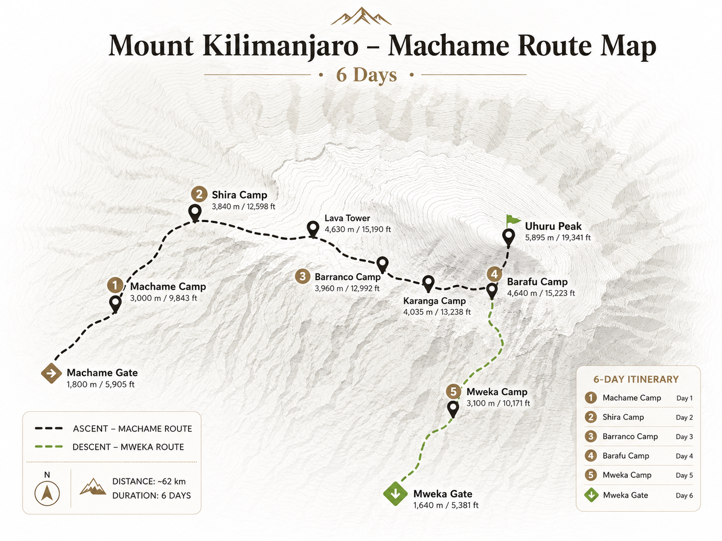
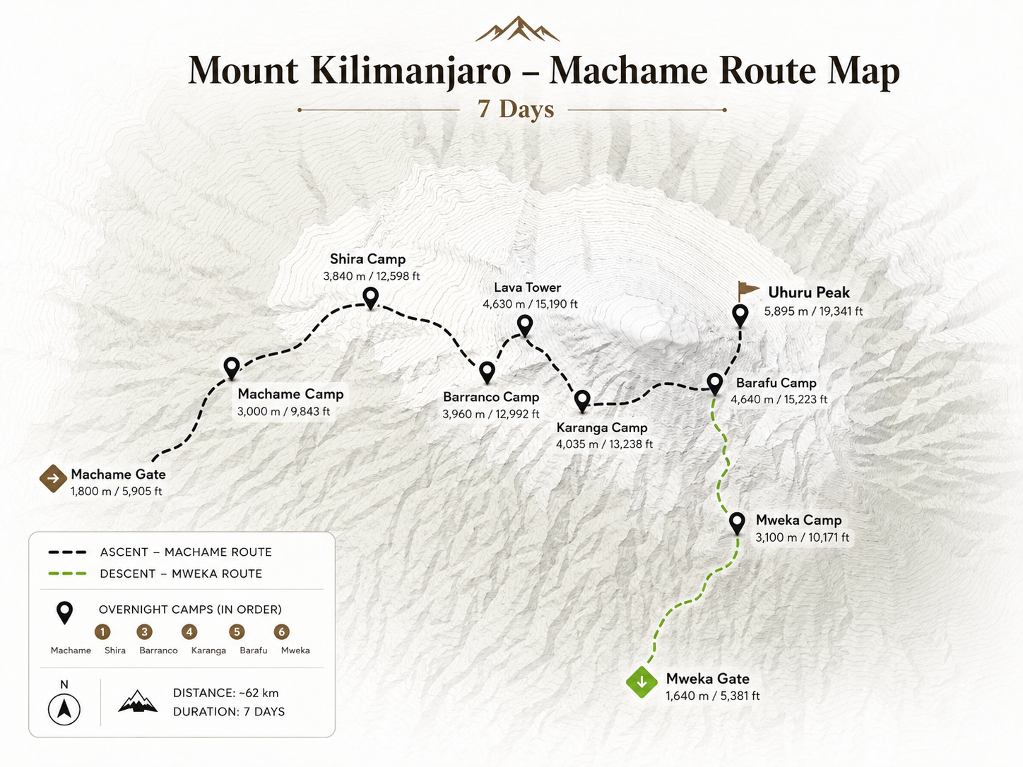
Machame Route on the Map
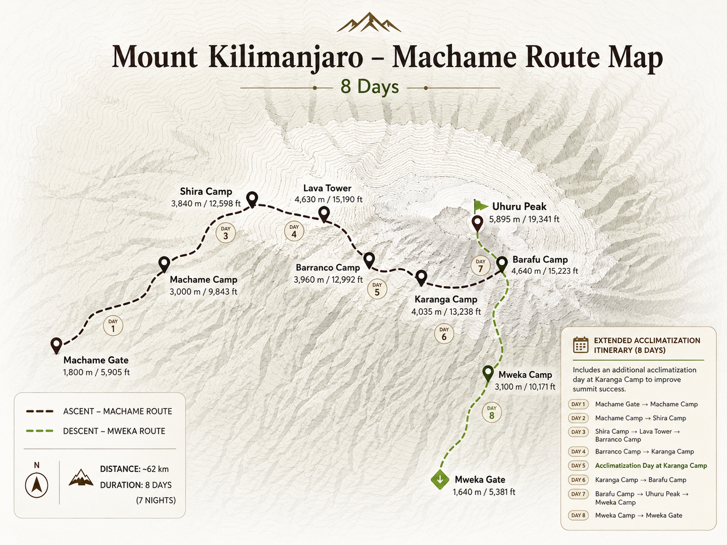
Visual Guide
Elevation Profile
Route Itinerary
After breakfast you drive from Moshi to Machame Gate, where your guides complete park registration and the porters pack the loads. The trail climbs steadily through dense rainforest of tall trees, moss and ferns, often muddy after rain, where colobus monkeys may be heard in the canopy. You reach Machame Camp in the afternoon, where your crew has set up the tents and prepared a hot meal.
Guide's note Hold back on the first day, even if you feel strong. The slow pace through the forest is deliberate, and it pays off higher up the mountain.
The forest gives way to giant heathers and open moorland as you climb a steep, rocky ridge. As the clouds clear, the summit of Kibo comes into view and the plains spread out below. The walk to Shira Camp is shorter than yesterday, leaving time to rest. Your guides check your oxygen levels and wellbeing every evening throughout the climb.
Guide's note As the views open up, take short breaks to look back down the mountain. Keep sipping water steadily through the day, even when the air feels cool.
A key acclimatisation day. You climb steadily across alpine desert to the Lava Tower, a volcanic rock formation at around 4,600m, where many people first feel the altitude. You then descend into the Barranco Valley, with its giant groundsels and towering cliffs, to sleep at Barranco Camp. Climbing high and sleeping lower helps your body adapt.
Guide's note Lava Tower is often where climbers first feel the altitude. Tell your guide about any headache; descending to sleep lower at camp tonight is exactly what helps the body adapt.
The morning starts with the Barranco Wall, a steep scramble where you sometimes use your hands on the rock. It is not technical climbing, and your guides help at the trickier steps, but a head for heights helps. From the top the views of Kibo's glaciers are superb. The trail then crosses several valleys to Karanga Camp, the last water point on the route.
Guide's note The Barranco Wall looks daunting from camp but is a scramble, not a technical climb. Keep your hands free, use the holds your guide shows you and take your time on the narrow section known as the kissing rock.
An acclimatisation day at Karanga Camp. After breakfast your guides take you on a short walk higher up the slope before returning to camp to rest, eat and drink well. Spending another night at this altitude gives your body more time to adapt before the final ascent, which can make summit night more manageable.
Guide's note Today the extra height is gained slowly and lost again before night. Mention any headache or loss of appetite to your guide; both are common and easier to manage early.
A short but steady climb over rocky ground brings you to Barafu Camp, the base for the summit attempt, on an exposed ridge with views of Mawenzi. You arrive around midday, eat an early dinner and try to sleep in the afternoon and early evening. Your guides prepare you for the night ahead, checking your health, clothing and equipment.
Guide's note The afternoon at high camp is for rest. Check your summit layers with your guide, eat a good early dinner and try to sleep, even if only for a few hours.
You start around midnight, climbing by headlamp up the steep scree slope towards Stella Point on the crater rim, which most climbers reach around sunrise. From there, conditions and your health permitting, it is about another hour to Uhuru Peak, the highest point in Africa at 5,895m. After photographs you descend to Barafu for a rest and continue all the way down to Mweka Gate. This is a very long and demanding day.
Guide's note Summit night is a slow, steady climb in the dark and cold. Follow your guide's pace, keep snacks and water close to your body, and remember that turning back is always a sound decision if your guide advises it.
the shape of the climb
How this climb unfolds
The seven-day Machame is the popular choice for good reason. After the forest, the Shira Plateau and the climb high to Lava Tower before sleeping at Barranco, you scramble up the Barranco Wall and spend an extra day at Karanga, so the final climb to Barafu feels steadier.
It suits first-time climbers who are reasonably fit and want a beautiful, varied route with good acclimatisation. It is busy in the main seasons, so expect company at camps, and a lively atmosphere on the trail.
zone by zone
The mountain on this route
Drink before you are thirsty and eat even when you are not hungry. At altitude, the small habits make the biggest difference.
From our mountain crewbefore you go
Preparing for the climb
other ways up
Related climbs

The Machame Route
View this climb
Machame Route, 8 Days
View this climb
Lemosho Route, 7 Days
View this climbplanned around you
Plan this climb with us
Tell us your preferred dates, group size and any previous experience at altitude. We will confirm the route, crew and hotel nights, and send a clear, personalised quote that lists exactly which park fees, equipment and transfers are included.
Overnight Stops
| Camp / Hut | Altitude | Zone | Night | Notes |
|---|---|---|---|---|
| Machame Camp | 3,100m | Rainforest | Night 1 | Ridge-top camp; forest views; tents |
| Shira Camp | 3,850m | Moorland | Night 2 | Plateau setting; afternoon acclimatization hike |
| Barranco Camp | 3,950m | Alpine | Night 3 (6-day) / Night 3-4 (7&8-day) | Dramatic cliffs; Baranco Wall in morning |
| Karanga Camp | 4,600m | Alpine Desert | Night 4 (6-day) / Night 4-5 (7&8-day) | Intimate camp; quiet setting; acclimatization day option |
| Barafu Camp | 4,673m | Alpine Desert | Night 5 (6-day) / Night 6 (7-day) / Night 7 (8-day) | Final camp; two-peak views; midnight departure |
| Uhuru Peak ★ | 5,895m | Arctic Zone | N/A | Africa's highest point; glaciers & crater; sunrise summit |