


Northern Circuit Route
The ultimate circumnavigation. Kilimanjaro's longest and most complete trek with 8-9 day options and glaciers visible on all four sides.
The Ultimate Circumnavigation
The Northern Circuit Route is Mount Kilimanjaro's longest, most exclusive, and most complete trekking path. At ~100 km, it offers the only full circumnavigation around Kibo Peak, showcasing glaciers on all four sides and delivering the most immersive wilderness experience on the mountain. This is the ultimate journey for those seeking complete adventure and the most remote Kilimanjaro experience.
The Northern Circuit's superior design combines the best acclimatization strategy with extraordinary visual rewards. Glaciers visible on every side, pristine remote camps, and the fewest summits of any route ensure maximum solitude and pristine wilderness. Success rates of 95-95%+ rival or exceed all other routes, thanks to expert acclimatization planning and the route's optimal design.
The route showcases Kilimanjaro's full ecological diversity: starting in forest zones at Londorosi Gate (the highest starting point at 2,100m), ascending through moorlands with panoramic Shira Plateau views, traversing alpine wilderness with all-around glacier viewing, and finally reaching the glacial summit zone. You'll experience complete circumnavigation with the most dramatic and varied mountain scenery on Earth.
Is Northern Circuit Right for You?
- LONGEST route complete circumnavigation of Kibo (~100 km)
- Glaciers on all four sides most complete glacier viewing experience
- Highest success rates 95-95%+ with optimal acclimatization
- Most REMOTE experience. Fewest summits, maximum solitude and wilderness
- Most COMPLETE Kilimanjaro experience full circumnavigation
- Exclusive route true wilderness adventure far from crowds
- Flexible duration. Choose 8 or 9 days based on fitness and acclimatization needs
- Tent camping required need sleeping bag and outdoor comfort
- Longest duration 8-9 days demands time and fitness commitment
- Most challenging terrain steepest ascents and most remote
- Highest cost. Reflects premium wilderness experience and service level
- Most remote evacuation limited emergency access in remote areas
Northern Circuit Route on the Map
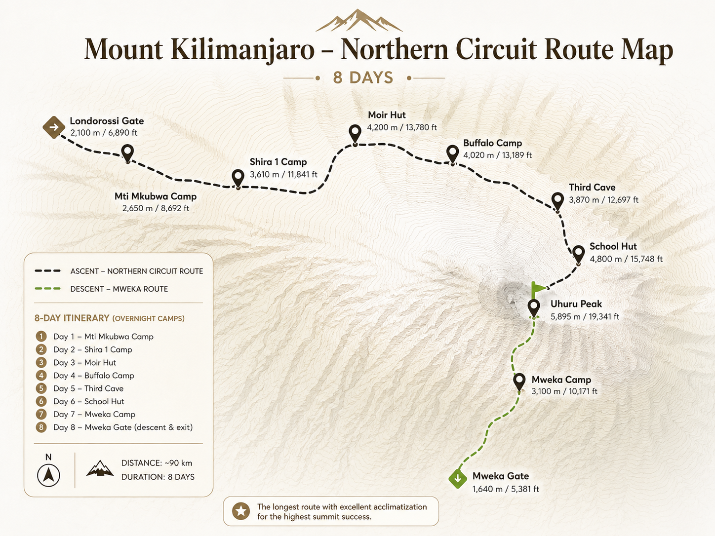
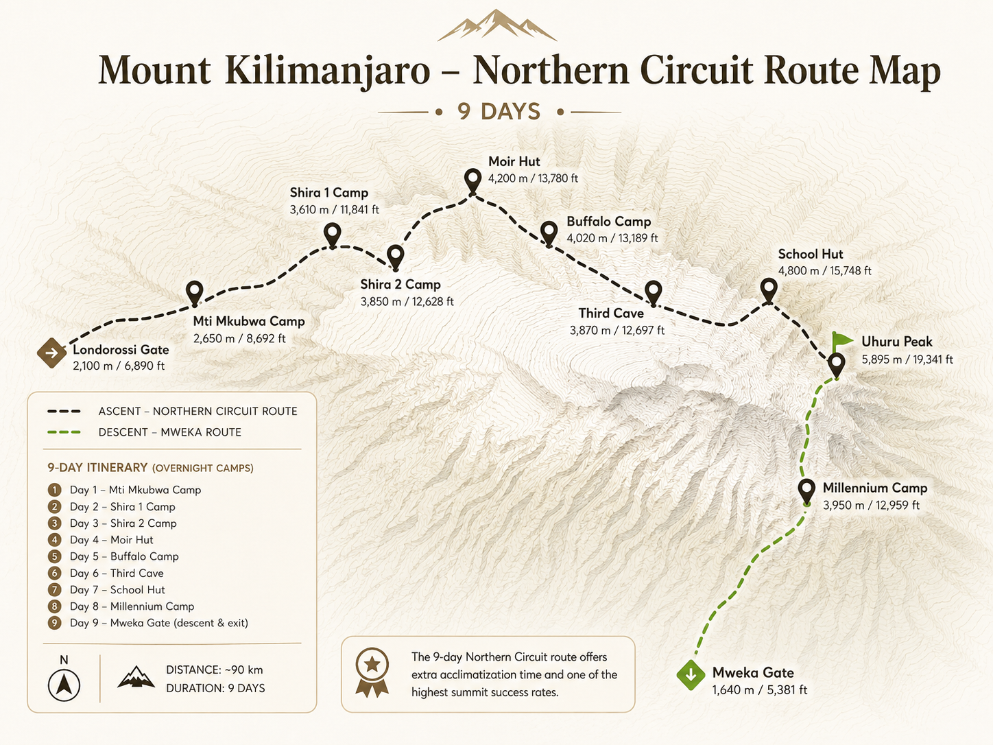
Visual Guide
Elevation Profile
Route Itinerary
Your Northern Circuit adventure begins at Londorosi Gate (2,250m) on the western side of Kilimanjaro. Your Haven Trails team completes all park registration and initial briefings at the gate, then you drive a short distance further up to the Lemosho trailhead in the glades. The trail enters lush montane rainforest immediately-dense, misty, and alive with birdsong and the crash of unseen wildlife. Ancient ferns, moss-draped trees, and towering podocarpus create a canopy overhead.
The path ascends gently through the forest zone, giving your legs a comfortable warm-up. You may spot Black and White Colobus monkeys leaping through the canopy and signs of buffalo that roam this area. After 3-4 hours of steady hiking, you arrive at Mti Mkubwa Camp (2,650m)-also known as Big Tree Camp-named for the enormous ancient trees surrounding it. Your porters will have arrived ahead of you and set up camp. Settle in with hot tea, freshen up, and enjoy your first mountain dinner.
Today you leave the dense rainforest behind as the trail climbs upward. The trees thin, replaced by giant heather and lichen-draped volcanic rock. You emerge dramatically onto the Shira Plateau-a vast open expanse that was once Kilimanjaro's third volcanic peak before it collapsed inward. The views open up magnificently, and for the first time you catch sight of Kibo peak towering above you to the east.
The trail traverses through the heather and moorland zone, with the distinctive giant senecios (tree groundsels) and lobelias lining the path like something from a prehistoric world. You'll go up and down several ridges as the route climbs to its highest point of the day around 3,500m before descending to Shira 1 Camp. After 5-6 hours you arrive at Shira 1 Camp (3,500m) on the plateau itself. Your guides lead a short acclimatization walk before dinner to help your body adjust to the altitude.
This is a landmark day on the Northern Circuit. You climb high and sleep low, one of the most powerful acclimatization strategies on the mountain. The morning begins with a traverse of the upper Shira Plateau past the Scott Fischer Memorial Camp (named for the legendary Everest guide). The path climbs steadily toward Lava Tower (4,600m), a dramatic volcanic plug and iconic Kilimanjaro landmark rising from the plateau.
You reach Lava Tower for a well-earned lunch, having climbed to over 4,600m. The highest you've been so far. This high-altitude exposure supercharges your acclimatization. After lunch, instead of pushing further up, the trail swings north and descends to Moir Hut Camp (4,200m). This descent is not retreat. It is strategy. Sleeping at a lower elevation after reaching a high point is the "climb high, sleep low" principle in action, dramatically improving your body's adaptation. Moir Hut is a remote, beautiful camp with sweeping views across the Shira Plateau and far-reaching plains beyond.
Today you leave the main Kilimanjaro trekking routes behind and begin the true Northern Circuit experience. A world of pristine solitude and wilderness that almost no other trekker sees. You climb steeply out of Moir Valley and take a short detour to the summit of Lent Hills (4,695m), where panoramic views of the northern slopes and the vast Kenyan plains beyond stretch out before you in every direction.
Returning to the main trail, you head eastward along the northern flank of the mountain. The path crosses a striking field of rock slabs that clink musically underfoot, then gently undulates through sparse high-altitude desert landscape. You arrive at Buffalo Camp (3,962m), a magnificently isolated camp with enormous skies. From here, looking north, the Kenyan plains seem to stretch on forever. You are now truly in the remote northern wilderness. This is Northern Circuit at its most untouched and spectacular.
Another magnificent day on the remote northern slopes. You begin by climbing Buffalo Ridge. A steady, breathtaking ascent. Then cross numerous ridges and gullies as the trail continues east around the mountain. The landscape becomes increasingly sparse: high alpine desert with angular volcanic rocks, thin vegetation and sweeping silence broken only by the wind. You are walking on Kilimanjaro's most untravelled ground.
Eventually you arrive at Third Cave Camp (3,871m), where trekkers coming up the Rongai Route from the north also converge. You've circumnavigated the entire northern face of the mountain and can now sense the eastern side of Kilimanjaro beginning. The camp is named for the three large caves nearby used as shelters by local herders in centuries past. The air is noticeably thinner now and your body. Having spent five days gradually ascending. Is adapting beautifully. Dinner, rest and a sky full of stars await.
Today is shorter in distance but significant in altitude gain. The trail climbs steadily through the Saddle. The vast, lunar landscape that stretches between the two peaks of Kibo and Mawenzi. The Saddle is one of Kilimanjaro's most otherworldly environments: a barren, windswept plain at nearly 4,500m with dramatic views in every direction. To your right, the jagged tooth of Mawenzi Peak (5,149m) pierces the sky. To your left, the smooth volcanic dome of Kibo looms massive and close.
You arrive at School Hut Camp (4,750m). Also known as Kibo Hut on some maps. Your base camp for the summit attempt. After a short rest, your guides conduct a comprehensive summit briefing: gear check, hydration strategy, pacing, what to expect on the ascent and emergency protocols. Eat as much dinner as you can stomach despite the altitude dampening your appetite. Then attempt to sleep. The alarm is set for midnight.
At midnight, your guides wake you. It's bitterly cold and your body protests leaving the warmth of your sleeping bag. But the adrenaline of summit day takes over. You layer up. Thermal base, fleece, insulated jacket, down parka, balaclava, thick gloves. Until only your eyes peer out from the layers. Your headlamp cuts through the absolute darkness as you take your first steps upward. The mountain is silent except for the crunch of boots on frozen scree and the sound of your own breathing.
The climb is relentless and humbling. "Pole pole". Step by step, breath by controlled breath. The scree switchbacks offer little traction and every step requires focused effort. Your guide stops every 30-45 minutes for short breaks and breathing checks. After five to seven hours of steady climbing in darkness, you crest the crater rim at Gilman's Point (5,756m) just as the most spectacular sunrise of your life blazes over Mawenzi Peak. Pink, orange, gold and infinite. Then the final 45-minute push along the crater rim, past towering glaciers and ice cliffs, to Uhuru Peak (5,895m). The roof of Africa. The moment is overwhelming. Tears, laughter, exhausted hugs and profound silence.
After summit photos and celebration, the descent begins. You descend via the Mweka route. A long, steep, leg-burning journey south. Pass through Barafu for a short rest and lunch, then continue to Mweka Camp (3,110m), arriving in the late afternoon. Your summit day totals 13-17 hours. Dinner, rest and deep sleep. You've earned every moment of it.
Your final day on Kilimanjaro. Your legs are heavy and your body aches from yesterday's epic summit push. But your heart is full and your spirit is soaring. The descent from Mweka Camp (3,110m) plunges back into the lush montane forest zone. As altitude drops, the air grows richer and breathing becomes easier with every step. Birds begin to sing again, the trees grow tall and warmth returns to the air. It's a beautiful, emotional farewell to the mountain.
After 3-5 hours, you reach Mweka Gate (1,640m). The end of the Northern Circuit. Here, the complete circumnavigation of Kilimanjaro is officially sealed. You have walked around, across and to the top of Africa's greatest mountain. A feat fewer than 5% of Kilimanjaro trekkers ever complete. Your porters and guides gather for a traditional celebration: singing, dancing, laughter and gratitude. You receive your official Kilimanjaro Summit Certificate. Gold for those who reached Uhuru Peak. Emotional farewells with your crew and then the drive back to Moshi and a long, well-earned hot shower.
Your Northern Circuit adventure begins at Londorosi Gate (2,250m) on the western side of Kilimanjaro. Your Haven Trails team completes all park registration and briefings, then you drive to the Lemosho trailhead in the glades. The trail enters the dense montane rainforest immediately. Lush, misty, alive with the crash of unseen wildlife and the calls of tropical birds. Ancient ferns, moss-wrapped trees and towering podocarpus form a cathedral canopy above you.
The path ascends gently, giving your legs a comfortable introduction to mountain trekking. Watch for Black and White Colobus monkeys leaping through the high canopy and signs of buffalo in the undergrowth. After a peaceful 3-4 hours, you arrive at Mti Mkubwa Camp (2,650m). "Big Tree Camp". Named for the magnificent ancient trees surrounding it. Porters have set up your tents and a hot dinner awaits.
The rainforest thins and gives way as you climb. Trees become heather-draped and shorter, then transition into open moorland dominated by giant senecios (tree groundsels) and lobelias. Bizarre, prehistoric plants that look like something out of a fantasy world. The trail traverses up and down several ridges, gaining altitude all the while, before you burst out onto the magnificent Shira Plateau.
For the first time, Kibo Peak comes into view. Massive, snow-capped and breathtaking. After 5-6 hours you arrive at Shira 1 Camp (3,500m), perched on the ancient caldera of Kilimanjaro's collapsed third peak. Your guides lead a short acclimatization hike before dinner, helping your body begin adapting to the altitude. Rest well. The journey has begun.
Today is an important acclimatization day. The 9-day route's key advantage begins here. You traverse the upper Shira Plateau, crossing grassy moorland and fascinating volcanic rock formations. A detour to Shira Cathedral (3,900m). A huge buttress of rock surrounded by spires. Rewards those with energy for the short climb, with unforgettable views of Mt. Meru floating above the clouds to the west.
You arrive at Shira 2 Camp (3,850m), also called Shira Hut, where you join Machame Route trekkers briefly before they diverge south. The views across the valley and up to the Western Breach of Kilimanjaro above are stunning. The plateau is exposed and temperatures drop sharply at night. Be prepared for sub-zero cold. An acclimatization walk further up the ridge before dinner maximizes your body's altitude adaptation.
One of the most important days of the entire trek. You climb steadily through the high alpine desert, following the main trail up to the iconic Lava Tower (4,600m). A dramatic volcanic plug formation flanked by the equally famous Shark's Tooth rock at the same altitude. Lunch at Lava Tower gives you time to soak in the extraordinary panoramic views and feel the altitude. At 4,600m, your body is experiencing its highest altitude yet. And this is intentional.
After lunch, the Northern Circuit diverges from other routes, heading north. You descend to Moir Hut Camp (4,200m). Sleeping lower than where you lunched, completing the powerful "climb high, sleep low" acclimatization cycle. Moir Hut is a beautiful, remote camp tucked behind a ridge with sweeping views of the Shira Plateau and the vast plains far below. From here, you say goodbye to the crowded southern routes. The Northern Circuit's true wilderness begins tomorrow.
THIS IS THE DEFINING DAY that makes the Northern Circuit truly unique. You leave the main Kilimanjaro trekking routes behind and enter the true Northern Circuit wilderness. A world of pristine solitude that almost no other trekker ever sees. You climb steeply out of Moir Valley and take a detour to the summit of Lent Hills (4,695m), where a 360-degree panorama of the northern slopes and the vast Kenyan plains unfolds before you in every direction.
Returning to the main trail, you head eastward along the mountain's remote northern flank. The path crosses a memorable field of rock slabs that clink musically underfoot, then undulates through high-altitude desert landscape of breathtaking, barren beauty. You arrive at Buffalo Camp (3,962m). A magnificently isolated camp. From here, looking north, the Kenyan plains seem to stretch on forever. You are now walking in the most untouched, exclusive wilderness on Kilimanjaro.
Another magnificent day on the remote northern slopes. You begin with a climb up Buffalo Ridge. A steady, breathtaking ascent. Then cross numerous ridges and gullies as the trail continues east around the mountain. The landscape grows increasingly sparse: high alpine desert with angular volcanic rocks, thin vegetation and sweeping silence broken only by the wind. This is Kilimanjaro at its most untravelled and profound.
You arrive at Third Cave Camp (3,871m), where trekkers from the Rongai Route also converge. Named for the three ancient rock caves nearby used by local herders for centuries, the camp marks an important moment. You've circumnavigated the entire northern face of Kilimanjaro. Your body has now spent six days gradually adapting to altitude, giving you the best possible platform for the summit push ahead.
Today is shorter in distance but significant in altitude. The trail climbs steadily through the Saddle. The vast, lunar landscape stretching between the peaks of Kibo and Mawenzi. The Saddle is one of Kilimanjaro's most otherworldly environments: a barren, windswept plain at nearly 4,500m, dramatic and humbling. To the right, the jagged tower of Mawenzi Peak (5,149m) pierces the sky. To the left, the smooth volcanic dome of Kibo looms massive and close.
You arrive at School Hut Camp (4,750m). Your base camp for the summit push. After a short rest, your guides conduct a full summit briefing: gear check, hydration and nutrition strategy, pacing, what to expect in the dark and emergency protocols. Eat as much dinner as you can manage. Attempt to sleep early. The alarm is set for midnight.
At midnight, your guides wake you. It's bitterly cold, exhausting. But adrenaline surges. You layer up completely: thermal base, fleece, insulated jacket, down parka, balaclava, thick gloves. Your headlamp cuts through absolute darkness as you take your first steps upward. The mountain is silent except for the crunch of boots on frozen scree and the sound of your own breathing.
The climb is relentless. "Pole pole". Step by step, breath by controlled breath. The scree switchbacks offer poor traction and every step demands focused effort. Your guide stops every 30-45 minutes for breaks and pulse checks. You're moving slowly but you're moving. Hours blur together in the cold and darkness. At dawn, you crest the crater rim at Gilman's Point (5,756m) just as the most spectacular sunrise of your life blazes over Mawenzi Peak. Then the final push along the crater rim. Past towering glaciers and ice cliffs. To Uhuru Peak (5,895m). The roof of Africa. Tears, laughter, exhausted hugs and profound silence.
After summit photos and celebration, the descent via the Mweka route begins. Long and steep, you pass through Barafu for lunch, then continue to Mweka Camp (3,110m). Your summit day totals 13-17 hours. Dinner, rest and sleep. You've earned every moment.
Your final day on Kilimanjaro. Your body aches from yesterday's epic summit push. But your heart is full and your spirit is soaring. The descent from Mweka Camp (3,110m) plunges into the lush montane forest. As altitude drops, the air grows richer and breathing becomes easier with every step. Birds begin to sing again. The trees grow tall and warm. It's a beautiful, emotional farewell to the mountain.
After 3-5 hours, you reach Mweka Gate (1,640m). The end of the Northern Circuit. The complete circumnavigation is officially sealed. You have walked around, across and to the top of Africa's greatest mountain. Your porters and guides gather for a traditional celebration: singing, dancing, laughter and gratitude. You receive your official Kilimanjaro Summit Certificate. Gold for those who reached Uhuru Peak. Emotional farewells with your crew, then the drive back to Moshi and a long, well-earned hot shower.
Overnight Stops
| Camp / Hut | Altitude | Zone | Night | Notes |
|---|---|---|---|---|
| Mti Mkubwa (Big Tree Camp) | 2,650m | Rainforest | Night 1 (both) | Forest gateway; named for giant trees; gentle first day |
| Shira 1 Camp | 3,500m | Moorland / Plateau | Night 2 (both) | Shira Plateau; first Kibo views; acclimatization walk |
| Shira 2 Camp (Shira Hut) | 3,850m | Alpine Plateau | Night 3 (9-day only ) | Key extra acclimatization night; Machame route meets here; Western Breach views |
| Moir Hut | 4,200m | Alpine Desert | Night 3 (8-day) / Night 4 (9-day) | Remote northern start; after "climb high, sleep low" from Lava Tower (4,600m) |
| Buffalo Camp | 3,962m | Alpine Desert | Night 4 (8-day) / Night 5 (9-day) | Panoramic Kenyan plains views; Northern Circuit wilderness begins; extreme solitude |
| Third Cave Camp | 3,871m | Alpine Desert | Night 5 (8-day) / Night 6 (9-day) | Eastern side of mountain; Rongai route converges; ancient herder caves nearby |
| School Hut (Kibo Hut) | 4,750m | Arctic / Scree | Night 6 (8-day) / Night 7 (9-day) | Base camp for summit; across the Saddle between Kibo & Mawenzi; midnight start |
| Uhuru Peak | 5,895m | Summit / Arctic | N/A | Africa's highest point; reached via Gilman's Point & Stella Point; sunrise views |
| Mweka Camp | 3,110m | Upper Forest | Night 7 (8-day) / Night 8 (9-day) | Post-summit descent camp; forest returns; last night on the mountain |